제이비어 브런슨(Xavier T. Brunson, 57) 주한미군사령관 겸 한미연합군사령관 겸 유엔군사령관은 장문의 기고문에서 동아시아를 거꾸로 바라보는 지도를 게재하고, 한국의 지정학적 중요성과 미국과 상호방위조약을 체결한 한국·일본·필리핀의 삼각협력을 강조했다. 브런슨의 '뒤집힌 지도'는 한국이 스스로 새로운 지도를 그려야 한다는 영감을 불어넣었다는 점에서 의미가 있다.
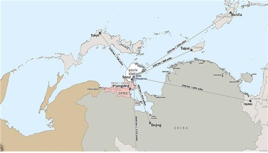
브런슨 사령관은 기고문에서 “한국은 중심부에서의 깊이, 일본은 기술우위와 해양도달 범위, 필리핀은 남쪽 해양축의 접근성을 제공하며 각자 고유한 능력을 보유하고 있다”고 밝혔다.
그는 “한국이 과거에 전방에 위치한 외곽거점처럼 인식됐으나 접근성, 도달성, 영향력을 갖춘 전략적 중심축(pivot)”이라면서 주한미군이 동북아 안정의 핵심기반 요소로서 가장 구체적이고, 실질적인 억제력이라고 강조했다.
브런슨의 ‘뒤집힌 지도’는 서울이 아니라 캠프 험프리스(평택 팽성읍)를 기준으로 평양(255km), 베이징(985km), 도쿄(1155km), 타이페이(1452km), 울란바트로(2045km), 마닐라(2550km), 하노이(2705km)와의 거리를 표시했다. 또한 평양과 블라디보스톡과의 거리는 691km로 나타났다.
이 지도에 표시되지 않았지만 서울과 험프리스는 75km, 서울과 평양( 195km)은 평양과 다렌(200km)과 차이가 없다. 평양과 베이징(1300km)은 험프리스와 타이페이보다 짧다.
군사전략의 관점에서 이뤄지는 한국에 대한 지정학적 재평가는 마찬가지로 조선의 지정학적 재평가를 초래한다. 단거리와 중거리 미사일의 성능이 고도화되는 시대에 캠프 험프리스의 해외분쟁 관여는 지리적으로 인접한 조·중·러의 길항작용을 부추길 수 있다.
다만 한반도가 이런 잠재적 리스크를 회피할 수 있다면, 가속화되는 미중대결의 전환기는 역설적으로 한반도의 평화안보와 국가이익을 조화하는 실리를 추구할 수 있는 기회적 요인을 제공한다. 한국이 핵추진 잠수함을 보유할 수 있게 된 것은 대표적 사례에 속한다.
전환기의 도전을 뚫고 경제적, 문화적으로 진일보하는 대한민국은 앞으로 핵추진잠수함을 비롯해 경항공모함 등 미진한 군사역량을 보완하여 국제적으로 ‘무위(武威)를 갖춘 중견국가’로 거듭나야 한다.
브런슨 지도의 양면성

브런슨 사령관의 ‘뒤집어진 지도’는 주한미군의 지속적 중요성을 강조하여 한국의 심리적 불안을 진정시키는 측면과 함께 한국을 대중(對中) 최전선으로 부각시켜 지정적 불안을 촉발하는 측면이 혼재한다.
그의 기고문은 트럼프 행정부의 주한미군 축소 및 분담금 압박과 국내 정치권 일각의 ‘미국의 도련선(島鏈線, island chain) 제외’ 주장이 맞물려 주한미군의 역할에 대한 논란이 가중되는 상황에서 신임 주한미군사령관으로서 미국의 새로운 아태군사전략을 밝힌 것으로 풀이된다.
(1950년 한국전쟁의 촉발원인으로 논란을 빚었던 미국의 제1도련선은 일본 및 류큐 열도, 타이완, 필리핀, 말라카해협으로 모두 섬과 해협으로 이뤄져 한반도가 제외됐었다.)
브런슨의 ‘뒤집힌 지도’는 한국의 군사전략적 중요성과 위상을 강조하지만, 동시에 신냉전이 강화되는 동북아에서 한국의 전략적 유연성을 제한하여 유사시에 해외의 전란에 휘말릴 수 있다는 것을 암시한다.
한국은 동북아 최적의 작전지역? 중국·대만전쟁의 항공모함?

이에 앞서 브런슨은 미 태평양지상군 심포지엄에서 한반도가 동북아에서 최적의 작전지역임을 강조하며 중국과 대만의 분쟁에서 항모 역할을 할 수 있다고 주장하면서 만약 자신이 정책결정권자라면 한반도에 기동부대를 다시 배치할 것이라고 말한 바 있다.
이러한 발언은 과거에 맥아더 사령관이 대만을 불침항모로 비유하고, 나카소네 일본 총리가 일본 열도를 불침항모로 비유했던 것을 연상케 한다. 미국은 동북아에서 대만, 일본에 이어 한국을 불침항모로 간주하겠다는 것인가?
그는 또한 미 상원 청문회에서 주한미군이 러시아와 중국 대처용이라고 언급한 바 있고, 한국의 조기대선 직전에 한미일 (군사)동맹을 강조하며 “대한민국의 새 지도자가 6월4일부터 ‘일종의 동맹(한미일 준동맹관계)’이 기로에 있다는 사실을 받아들여야 한다”고 압박하기도 했다.
전환기 국가전략 : 20세기 양비론에서 21세기 양시론으로
한국은 경제선진국 진입에 이어 K-컬처 및 소프트파워의 신장으로 동아시아의 중심국가, 글로벌 중견국가의 하나로 자리잡은 마당에 미국의 군사전략적 중심축이라는 규정은 반드시 달갑지만은 않은 이중적 의미가 있다.
한국은 미국과의 동맹관계를 통해 조선과 중국의 군사적 위협을 억지해야 하지만, 동시에 각 부문의 경쟁국이자 역사적으로 잠재적 가상적국인 일본에 대한 감시도 소홀히 할 수 없다.
또한 한국은 이탈리아와 함께 대표적 반도국가로서 스스로 자기 힘과 외교노선이 미흡하면 대륙세력(land powers)과 해양세력(sea powers)의 각축에 휘말려 주권이 훼손되거나 전란에 휘말릴 수 있다. 한국은 평화시에 중국과일본의 중간자로서 양측과 동시에 경제협력을 유지 및 매개하는 교량자적 역할에서 여러 가지 국가적 유익을 추구할 수 있다.
브런슨의 ‘뒤집힌 지도’는 한국의 대중 군사전략적 위상을 강조한 것으로 일면 한미동맹의 지속성을 뒷받침하는 지정학적 근거이지만, 동시에 한국이 동아시아와 세계에서 추구해야 할 다면적 역할 및 위상을 소거한 것이다. 즉 ‘뒤집힌 지도’는 한반도의 평화와 동아시아의 공동번영을 위한 한국의 미래지향적 역할을 위해 재해석될 필요가 있다.
지정학적으로 허약한 완충국가였던 한반도는 중세 이후 무장중립의 역량이 부재하여 대륙세력과 해양세력의 패권경쟁에서 전쟁터로 전락하면서 양비론적(반중·반미) 민족주의가 뿌리깊게 자리잡았고, 현대의 한반도 국가는 한국과 조선으로 분립됐다.
하지만 21세기 한국은 내적으로 양비론의 타성에서 벗어나 양시론(친미·친중)으로 대륙과 해양의 교량자로서 잠재력을 극대화할 수 있도록 국력과 국제적 위상을 냉정하게 점검하고 이를 제고하는 국가전략이 필요하다. 그것은 베이징-평양-서울-도쿄의 평화적 공존을 기본으로 하는 현상유지와 세력균형을 전제하면서도 '적대적 두 국가'로 전환기를 맞이한 남북관계에 대한 새로운 전략이 중심축(pivot)이 되어야 할 것이다.
주한미군사령관 기고문(원문)
The East-Up Map: Revealing Hidden Strategic Advantages in the Indo-Pacific
By Gen. Xavier T. Brunson, Commander of United Nations Command, Combined Forces Command and United States Forces Korea
How a simple change in map perspective can transform strategic understanding, and how we understand the battle space.
The most profound strategic insights sometimes emerge from the simplest shifts in perspective. In the Indo-Pacific theater, where geographic relationships determine operational possibilities and alliance effectiveness, military planners may be overlooking critical advantages simply because of how they view their maps. By rotating our standard north-up orientation to place east at the top, a transformed strategic landscape emerges--one that reveals previously hidden geographic relationships and illuminates why current force positioning may be more advantageous than traditionally understood.
The Blind Spots of North-Up Thinking
Military education trains officers to analyze terrain, but we rarely examine how the orientation of our maps shapes that analysis. The standard north-up projection, with North America centered and prominent, creates an analytical framework that may obscure strategic realities in other theaters. This perspective, while familiar, can generate blind spots that limit strategic effectiveness.
Consider how this traditional view presents the Indo-Pacific: as a vast expanse with scattered islands and distant allies, where American forces must project power across enormous distances to reach potential conflict zones. This perspective emphasizes the challenges of power projection while minimizing existing advantages.
The Strategic Revelation: East-Up Mapping
When the same region is viewed with east orientation toward the top, the strategic picture transforms dramatically. The first island chain, a cornerstone of Indo-Pacific strategy, takes on new meaning. Forces already positioned on the Korean Peninsula are revealed not as distant assets requiring reinforcement, but as troops already positioned inside the bubble perimeter that the U.S. would need to penetrate in the event of crisis or contingency.
This shift in perspective illuminates Korea's role as a natural strategic pivot. Distance analysis reveals the Camp Humphreys' proximity to potential threats: approximately 158 miles from Pyongyang, 612 miles from Beijing and approximately 500 miles from Vladivostok. Korea is positioned to address northern threats from Russia while simultaneously providing western reach against Chinese activities in the waters between Korea and China. More specifically, this perspective highlights the peninsula's capacity to impose cost on Russia not allowing their fleet to come into the waters east of Korea, effectively making that a more defensible maritime area and limiting adversary naval movements. Similarly, in the waters off the west coast of Korea, the East-Up orientation clarifies how forces on the peninsula can impose costs, not only on the CCP’s Northern Theater Army, but also on the Northern Fleet, thus demonstrating the significant strategic potential that exists on the peninsula to influence adversary operations in both adjacent seas.
The strategic value becomes even clearer when viewed from what I call the "Beijing perspective," imagining the strategic landscape as it appears to Chinese planners. From Beijing, American forces at installations like Osan Air Base appear not as distant threats requiring complex power projection, but as immediately proximate capabilities positioned to achieve effects in or around China. This proximity represents a significant strategic advantage that traditional north-up mapping tends to obscure.
These operational insights demonstrate that east-up mapping provides more than theoretical understanding, and it enables practical strategic planning that leverages existing geographic advantages.
The Strategic Triangle: A New Framework for Alliance Cooperation
Perhaps the most significant insight from east-up mapping is the emergence of a strategic triangle connecting Korea, Japan, and the Philippines. When these three mutual defense treaty partners are viewed as vertices of a triangle rather than isolated bilateral relationships, their collective potential becomes clear.
This triangular framework offers complementary capabilities across each vertex. Korea provides strategic depth and central positioning within the regional architecture, with the added advantage of cost-imposition capabilities against both Russian and Chinese forces. Japan contributes advanced technological capabilities and controls critical maritime chokepoints along the Pacific shipping lanes. The Philippines offers southern access points and control over vital sea lanes connecting the Pacific and Indian Oceans.
Together, these three allies can create an integrated network enabling situational awareness and coordinated responses across all domains. The geometric clarity of this relationship, visible primarily through east-up mapping, suggests opportunities for enhanced trilateral cooperation that may not be immediately apparent from traditional perspectives.
The Tyranny of Distance Reconsidered
Military planners frequently refer to the "tyranny of distance" as a constraint on Indo-Pacific operations. While distance remains a critical factor, east-up mapping reveals that current positioning may offer advantages that traditional perspectives obscure. The scale of the Pacific creates operational challenges, but it also creates opportunities for those already positioned within the theater.
The command perspective reinforces this point: rather than focusing solely on the challenges of power projection across the vast distances of the Pacific, planners should recognize that strategic positioning already achieved can transform distance from obstacle to advantage. When forces are properly positioned within the theater, they can impose costs on adversaries while maintaining defensive advantages.
Understanding these geographic relationships through multiple perspectives enables more accurate operational planning and resource allocation. Distance remains a constraint, but proper positioning can transform it from an insurmountable obstacle into a manageable challenge.
Operational Implications for Force Planning
These insights carry practical implications for contemporary force planning.
First, existing force positioning, particularly on the Korean Peninsula, may offer greater strategic advantages than currently recognized. Rather than viewing these deployments as vulnerable forward positions requiring reinforcement, planners might consider them as advantageously positioned assets already inside the defensive perimeter, capable of immediate cost-imposition against multiple adversaries.
Second, the strategic triangle framework suggests possibilities for enhanced burden-sharing and coordinated capability development among alliance partners. Rather than maintaining separate bilateral relationships, the United States might benefit from fostering trilateral cooperation that leverages each partner's geographic advantages and complementary capabilities.
Third, operational planning should incorporate multiple cartographic perspectives to avoid analytical blind spots. Standard north-up mapping remains useful for certain purposes, but alternative orientations may reveal strategic opportunities that remain hidden in conventional presentations. The "Beijing perspective" approach, in particular, helps planners understand how adversaries view American positioning and identify advantages that might otherwise go unrecognized.
Challenging Strategic Assumptions
This exercise represents a broader imperative: the need to challenge fundamental assumptions in strategic planning. The security environment continues to evolve, and analytical frameworks must evolve accordingly. We cannot assume that traditional approaches to regional analysis remain optimal simply because they are familiar.
Strategic planners should regularly question basic assumptions about positioning, alliance relationships, and operational approaches. What appears disadvantageous from one perspective may reveal significant advantages when viewed differently. In an era of strategic competition, such insights could prove decisive.
Moving Forward: Implementation and Analysis
Military educational institutions should incorporate alternative map perspectives into their curriculum, educating students to analyze the same geographic space through multiple orientational frameworks. War colleges should include exercises that specifically examine how different map orientations affect strategic assessment, including the "Beijing perspective" approach that helps understand adversary viewpoints.
Operational planners should experiment with east-up mapping when conducting Indo-Pacific analysis, particularly when examining alliance coordination opportunities and assessing existing force positioning advantages. The geometric clarity of the Korea-Japan-Philippines triangle becomes most apparent through this alternative perspective, while the cost-imposition capabilities visible from Korean positioning provide concrete operational advantages.
Additionally, strategic communication with allies and partners across the region should incorporate these alternative perspectives to build shared understanding of geographic relationships and mutual advantages. The strategic triangle concept, in particular, may provide a useful framework for trilateral planning discussions that move beyond traditional bilateral alliance structures.
Conclusion
Geography remains the foundation of strategy, but our understanding of geography depends heavily on how we choose to view it. The east-up mapping approach reveals strategic relationships and advantages in the Indo-Pacific that remain obscured by traditional north-up orientations. Most significantly, it illuminates the potential of the Korea-Japan-Philippines strategic triangle as a framework for enhanced alliance cooperation, while demonstrating the immediate cost-imposition capabilities that existing force positioning already provides.
In an era of renewed strategic competition, we cannot afford to let conventional map perspectives limit our strategic imagination. The geographic advantages we seek may already exist, waiting to be recognized through a simple shift in perspective. The question for military planners is not whether geography matters, it is whether we are seeing it clearly enough to recognize the strategic opportunities it provides, and whether we have the courage to view familiar perspectives through fresh eyes.
Sometimes the most profound strategic revelations come from the simplest change in how we look at the world. The east-up map is one such change, transforming distant challenges into proximate advantages and revealing the hidden geometry of alliance cooperation in the Indo-Pacific.
'미들파워(Middle Power) > 중견국가의 지표' 카테고리의 다른 글
| 헨리 여권지수, 한국 3위에서 2위로 상승 (2) | 2026.01.15 |
|---|---|
| 니혼게이자이, ‘한일 미들파워 제휴’ 눈길 (1) | 2026.01.09 |
| 보호필요아동 수십명 강제전학 논란 (0) | 2025.11.12 |
| 카이스트의 굴욕, QS 아시아 대학평가 실격. 연대 11위, 고대 12위 (3) | 2025.11.04 |
| 트럼프의 약탈적 관세와 한미 FTA 삭제 (1) | 2025.10.31 |